 •
Rating:
•
Rating:
THE REVIEW
I woke up early this morning, as is my long-standing habit. The weather conditions are not the best, with scattered clouds and a chance of rain from early afternoon. I've been planning this new ascent among my mountains for days, and nothing can stop me; I have a good breakfast and at 8 o'clock, I leave the house. A temperature typical of late autumn immediately envelopes me: the altimeter tells me it's 10 degrees, but the cold doesn't scare me.
I reach the hamlet of Asparedo and leave the paved road to venture onto a well-marked forest path, which is starting to take on the typical colors of the season. I need to pay attention because the fallen leaves are a hazard to my progress, making the path treacherous and slippery; I maintain a good pace this way, without exaggerating because today's route is very long. Here I am at Vallesone, where I take the first short break, taking off the down jacket I'm wearing: I'm starting to get hot despite the decidedly brisk air.
Given the poor condition of the paths filled with many fallen leaves, I decide to continue on the carriageway, which allows me to reach Alpe Lusentino around 9:30. Unfortunately, visibility is not the best, and the first clouds begin to form, wrapping around the mountains above me; at the moment, there's not even a hint of the much-awaited sun, and it will stay that way for the entire hike. The comfortable road ends here, and there's nothing left to do but get back on the path, which at the moment crosses treeless meadows, allowing me to proceed without problems. In quick succession, I leave behind the pastures of Foppiano and Torcelli and reach Casalavera at 1600 meters high; the altimeter tells me we've dropped to 5 degrees, but I don't notice the cold. I'm used to such temperatures, which, to be honest, I love; I was born among these immense mountains. Cold and snow are at home here in Ossola, from October to late spring.
Another brief pause to eat an energy bar and drink some chilly water!! I notice that a few dozen meters below me, someone is climbing the same path; I decide to wait for them. We walk together for a few minutes, and then our paths separate because he turns towards Moncucco, while I start along the ridge that in another half hour will take me to Colle del Pianino. It's the most dangerous stretch because now the path heads north and I have to walk icy sections with a good quantity of slippery frost; I must pay the utmost attention because I'm on a ridge, and there are sheer drops of a few hundred meters below me.
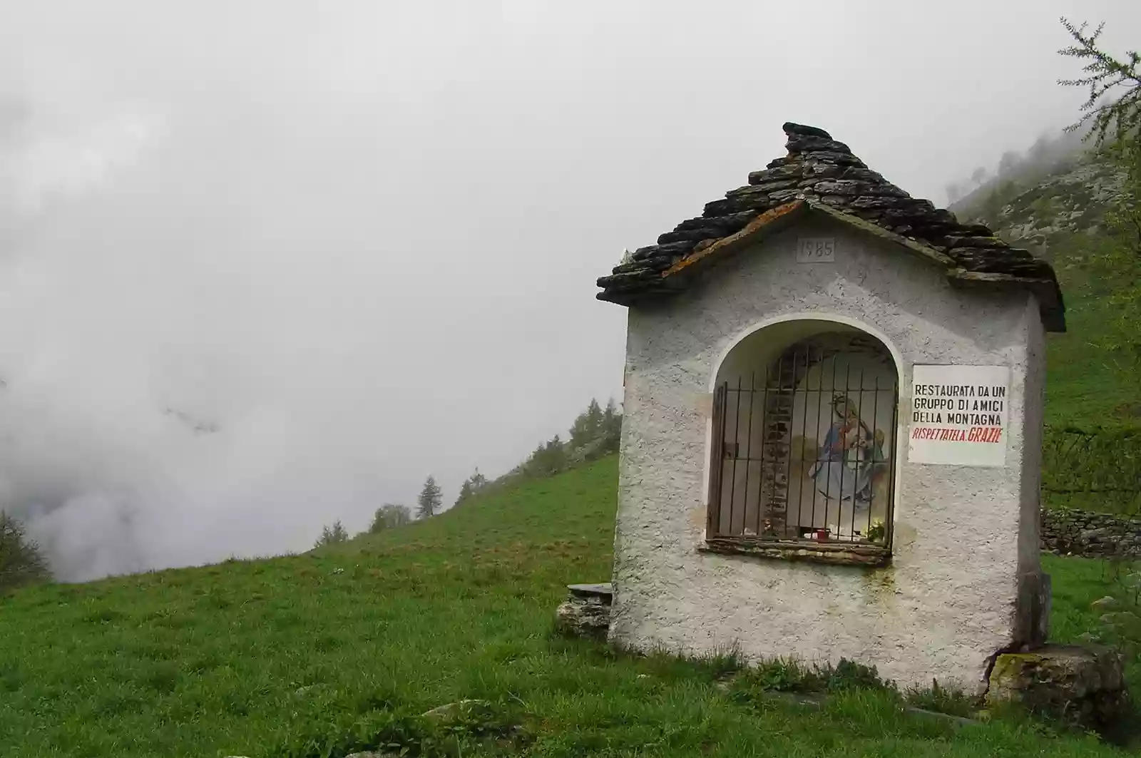
There it is, I see the votive chapel that's the signal of my arrival at Pianino; I'm on the watershed between two important valleys. To the left is the Antrona Valley, and to the right is the Bognanco Valley. Unfortunately, the fog doesn't allow me to "binocular" the peaks in the area, which in some cases reach and exceed 3000 meters; another glance at the altimeter confirms that I have reached an altitude of 1620 meters. It also tells me that the outside temperature has dropped to just 3 degrees; it is exactly 11 o'clock. In three hours, I have surpassed a significant elevation change, and now the descent awaits me; I decide to descend on the side of the Bognanco Valley on a not too well-marked path. For this reason, a couple of times, I'm forced to go back, having lost track of the path to take; slowly, I'm able to find the right way, crossing a couple of now abandoned pastures.
On the quick descent, two things improve: visibility, because I've left the fog behind, and the temperature, which finally begins to rise, although it will never exceed 10 degrees. The path crosses ancient forests of chestnuts, beeches, and larches; I meet a good number of people busy searching for mushrooms and indeed chestnuts. After an hour of descent, I find myself in the village of Pioi, in the municipality of Bognanco; I've descended to about 900 meters of altitude. Here I decide to take the longest break to enjoy for lunch two sandwiches; I have time to recognize in front of me the imposing and familiar shape of Cima di Lariè, Cima di Camughera, Passo del Monscera that connects Italy to Switzerland.
I can't stop for too long, also because the weather forecast predicts rain from early afternoon; as they say in my region "cià che numa, gh'è mia temp da perda". Translated, one could say: get a move on and move at a good pace; and that's what I do. I dive back into the woods for the last part of the long walk; more pastures this time very well-kept like the picturesque cluster of a few houses called Pontasca. The descent continues, much gentler compared to the first part and here I am in another postcard-perfect place. The wonderful locality of Bei still inhabited all year round by a few families; fatigue begins to set in, and my legs call for another brief pause. I satisfy their need but cannot afford too much time because menacing clouds are gathering towards Domodossola.
I exit the forest and for a few hundred meters, I have to retrace the not so loved paved road; three, two, one curve, and a short straight. I see the black roof of my house; I've arrived in Maggianigo, my village, and it's just past 2 o'clock.
A long loop where I will have covered about twenty kilometers; I haven't brought a smartphone, and as a result, I haven't listened to any music. Alone and in silence to better listen to the breath, the unique and unrepeatable sounds of my mountains...and the infinite silences.
Solo hike, as almost always happens to me, having time to think and dedicate this my humble writing to a recently deceased friend, who like me loved these places...To you Nunzio, my dear friend...
Ad Maiora.
Loading comments slowly
Summary by Bot
The reviewer describes a solo autumn hike to Colle del Pianino, starting early despite uncertain weather. The route presents slippery paths and fog, but also serene mountain scenes. The journey is marked by personal reflection and the joy of nature’s silence. Despite challenges, the hike is fulfilling and concludes safely at the village.
